Search
Sugar Planatations Map of Barbados by Francis Barrallier 1825. Showing the surnames of the owners of the major sugar plantations nine years before emancipation.
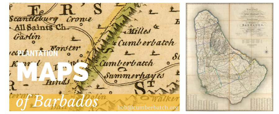
Sugar Planatations Map of Barbados by Francis Barrallier 1st June 1825
Sugar Planatations Map of Barbados by Francis Barrallier 1825. Showing the surnames of the owners of the major sugar plantations nine years before emancipation.
Barbados Plantation Owners & Plantation Names
To His Excellency the Rt. Hon’ble Stapleton Lord Combermere Commander in Chief of the Army in India, Colonel of the 3rd. Regiment of Dragoons, GCB, GCH, KTS, KSF &c. &c. &c. Late Commander of the Forces in the Windward and Leeward Charibee Islands &c. &c. &c. and Governor of Barbados, and to a liberal patron Gibbes Walker Jordan, Esqr. F.R.S. the late Colonel Agent for that island This trigonometrical survey [of Bardados] is most respectfully dedicated by their most obedient humble servant F. Barrallier, Captain H[alf] P[ay] 25th, Light Dragoons.
Map of Barbados in a trigonometrical survey. Map shows land ownership, shallows, rivers, and roads. Below the title, to the NE of the island, are tabulated 41 heights under the heading “Heights in feet above the level of the sea of all the principal stations of the survey.”
There is a tabulation of “Owners names” alongside “Names of plantation or places,” in lower corners, listing proprietors by parishes. With compass star. Alongside Barrallier’s signature is decoratively engraved “London 1st June 1825./Engraved by J. & C. Walker.” Prime meridian: Greenwich. Expressed in a scale of links and of hundreds of feet.
Source: JCB Map Collection
| Owner’s Surname | Owner’s Forename | Plantation Name | Parish |
| Cumberbatch | A.P. [Abraham Parry] | Clelands | St Andrew |
| Cumberbatch | A.P. [Abraham Parry] | Breedys | St Andrew |
| Cumberbatch | L. & E. [Lawrence & Edward] | Ebworth | St Peter |
| Cumberbatch | L. & E. [Lawrence & Edward] | St Nicholas Abbey | St Peter |
| Cumberbatch | A.P. [Abraham Parry] | The Farm | St Peter |